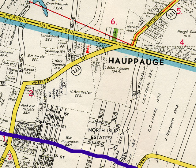
- The blue line is the approximate route of the Long Island Expressway (it did not exist when the map was made). The number 1. shows the the approximate location of exit 56.
- This indicates the property that Bud Land pointed out numerous times while riding through the area as the property owned by Law and Eliazbeth Land. However, I believe that he was mistaken. I cannot find any connection of any Land family to this piece of property.
- Addie Land married Ed Moseley. I do not know if this was where they lived. They were listed on Islip Road in Smithtown in the 1915 State Census They were listed on Maple Avenue, Smithtown in the 1930 Federal Census.
- This is the property originally purchased by Lydia Law Land in 1899 and perchased from her
by her son, Law
Land, in 1901.
In 1919 Percy bought a property which was discribed on the deed as:
ALL that certain tract or parcel of land with the buildings and improvements theren (sic), situate, lying and being at Hauppauge, in the Town of Smithtown, County of Suffolk, and State of New York, bounded North by land of E. Morris; East by land of George McCrone; South by the highway running along the town line between Smithtown and Islip; and west by land of A. Turak. CONTAINING two acres (2) more or less.
The land which on this map is owned by Margaret Dunn was formerly owned by E Morris. Percy must have bought one or both of the parcels near #4 that are listed on this map as Davis and Lewis. - Ethel Land married Frank Courier. They were listed from 1915 until 1930 on Hauppauge Road in Hauppauge.
- Hauppauge United Methodist Church and Cemetery